Please welcome the winning pictures of Wiki Loves Earth in Morocco!
Morocco has participated in Wiki Loves Earth 2015 and around 1700+ pictures have been uploaded under creative commons license through this event. This year we received around 3 thousand photos and it’s just great! 19 are already recognized as quality images on Wikimedia Commons and more to come.
577 participants took part in the contest and almost all of them are newbies. We are happy to introduce new people into the wiki world 🙂 Lets work on using these images, we now have, in Wikipedia articles!
Ten best pictures of Morocco this year you see below. You are free to reuse them, but please mention the author and the license.
Dam Moulay Youssef, Marrakech Province by Simosure, freely licensed under CC BY-SA 4.0
A landscape in Morocco by Othmane.elam, freely licensed under CC BY-SA 4.0
An Addax in the station of aclimation Safia, south of Dakhla by Haytem93, freely licensed under CC BY-SA 4.0
Erg Chebbi, Merzouga by Lefidele, freely licensed under CC BY-SA 4.0
Aïn Zarka, Tetouan Province by Mohamed Haddi, freely licensed under CC BY-SA 4.0
The Cave of the Camel, Berkane Province by Soufianerrami, freely licensed under CC BY-SA 4.0
Panorama of Djebel Toubkal by Webster93, freely licensed under CC BY-SA 4.0
Merzouga by Hzidane10, freely licensed under CC BY-SA 4.0
Barbary macaque in Azrou by Kamil-laghjichi, freely licensed under CC BY-SA 4.0
Azilal by Marahlija, freely licensed under CC BY-SA 4.0
One more country to reveal its top-10 pictures. Wiki Loves Earth 2016 in Thailand took place in June. 148 National parks in Thailand were eligible sites to upload their pictures on Wikimedia Commons. 422 new images we now have from these parks — isn’t that great? 🙂
Please, may your eyes rest on these wonderful pictures.
712 images were received for Wiki Loves Earth 2016 in Tunisia in total. 5% of them are already used in Wikipedia articles. You can help raise this percent by adding images into the articles yourself 🙂
47 authors uploaded their images for the contest — and 28 of them, it means more that a half, registered just to take part. Thank you all!
In the entire competition of Wiki Loves Earth 2016 in Nepal, 271 user participated and uploaded their images of the natural heritage sites of Nepal to Wikimedia Commons. Top uploader of the competition is user Indra Rai who donated 264 files, the second and third uploaders are users Bijay chaurasia and Nabin845 with 93 and 92 files respectively.
To felicitate the winners of the Wiki Loves Earth 2016 in Nepal, Maithili Wikimedians organized an event on 9th July, 2016. It was held in Masala Cottage, Kathmandu and was visited by 75 people. Winners received their prizes and were praised a lot for capturing such marvelous places of the country.
Ka Bo Kwong (1st winner) receiving her prize money. Photo by Bijay chaurasia, CC BY-SA 4.0Marija Gurjovska (2nd winner) receiving her prize money. Photo by Bijay chaurasia, CC BY-SA 4.0Pratap Baniya (3rd winner) speaking about the photo. Photo by Bijay chaurasia, CC BY-SA 4.0
The organizers thank to all the participants who took part in the contest. Thanks to you Wikipedia and other Wikimedia projects have now more wonderful photos of wonderful country — Nepal.
She is Katerina Zareva-Simeonova. She was the Bulgarian representative in the nine-person jury last year, which evaluated the photos at the International stage in the “Wiki Loves Earth” contest. The curious detail is that in 2015 the contest was organized in a total number of 26 countries, but not all of them had representatives in the jury. Bulgaria was invited to appoint a jury member, although the country takes part in the contest for the first time.
Due to the contest specifics, the appointed jury member had to be a biologist or ecologist with experience in photography. Katya is much more than that – she is also a big friend of the Free Encyclopedia. 🙂
After the “Wiki Loves Earth” contest finished and we announced the results, we asked Katya for an interview. We wanted to learn what it means to be a juror in a contest with so many breath-taking pictures…
Katya, present yourself in a couple of words. 🙂
My name is Katerina Zareva-Simeonova, I live in Sofia and my formal education is ecology. I have been working for 17 years in the Sofia Zoo, and I am currently the head of the Ecological scientific-educational centre in the Zoo. This is the department that accomplishes the Zoo’s function of providing education in ecology, develop educational materials and projects, one of which was the joint project with the Bulgarian version of the Free Encyclopedia Wikipedia.
Apart from the area of zoology, my interests are related to photography and popular science documentaries. I have published photos of animals and nature in various journals and books, and I have authored more than 100 educational and documentary ecological films, mainly about Bulgarian nature.
You have been juror in other photo contests, too. Tell us more about them, and what made the difference with the “Wiki Loves Earth” contest?
Yes, I have juried for competitions for children photographs and pictures, as well for film competitions on national level. For me, it was a great pleasure to be part of the International Jury of such a public photo competition like WLE, with already shortlisted pictures from 26 countries around the world. We had to review and evaluate 259 photos, showing the nature and biodiversity in the protected areas in these countries. For this purpose, we were provided with a special software tool and system for evaluation, helping jurors to calmly and independently evaluate all the photos.
What were the criteria, which the jury used to evaluate the photos. What was the most difficult part of the contest for you?
The criteria for the “Wiki Loves Monuments” contest are specific, since the contest has the certain goal of stimulating people to take pictures of the nature in their countries and create and extend the freely licensed information in Wikipedia, and in Commons in particular. For this reason, the criteria of evaluation were: technical quality, originality, and encyclopedic and educational value.
What hindered me was the huge choice of pictures of high quality and intriguing content. That was challenging for my evaluation, that had to be a very accurate and objective one. In the same time, that was for me a thrilling aesthetic and cultural experience, unveiling for me unbelievably beautiful natural landmarks and sceneries I haven’t expected to exist. I think that the concourse delivered its message and accomplished its mission, getting me to know and love the Earth even more than before!
None of the Bulgarian photos has been distinguished among the Top 15. What did we miss, in your opinion?
The winning pictures from the Bulgarian national stage of the competition depicted landscapes and animals from the natural parks of Rousse Lom River, Vratsa Balkan, Belasitsa, Belogradchik Rocks, Strandzha, Pirin and Rila mountains. All of them were gorgeous and rightfully represent our nature. At least for me, the pictures that affected me mostly, were the Belogradchik Rocks and the panorama view from Peak Vihren in Pirin.
However, the competition was really tough, and I think that our pictures lacked some originality. Both the audience and the jury are satiated with visual information, they want more colour, more of the wow-effect. It’s no surprise that the winning picture is a landscape from Pakistan, featuring buildings. Humans need to see themselves and the trace they leave onto nature, in order to compare themselves with it.
Katya, you are the head of the Ecological scientific-educational centre in the Sofia Zoo. In your opinion, how such photo contests contribute to raising the society’s awareness about environmental issues?
First, the contest participants have the opportunity to express their attitude to nature and show a favourite place or animal of theirs. On the other hand, in this very competition, where images are made freely available, this message reverberates, carries knowledge, and is capable of changing the mindset of many people.
I believe that nowadays, when people are impatient enough to watch even several minutes of a video in the Internet, photography has a particularly pronounced and direct impact. An image can take the breath away and cause great excitement, especially if it captures a beautiful natural landscape. I still think that beauty can save the world, and this is why I rely on it, rather than on the aesthetic of ugliness or of shocking imagery.
Which picture was your personal favourite?
I won’t try to hide that for me the most interesting photos were the ones depicting animals. This is my field of expertise, and I well know how hard it is to take a picture of an animal, especially in wildlife. My favourite photo, which turned out to be favourite for the rest of the jury members as well, came from Brazil and captured the moment of birth of an Apis Mellifera drone. That image received the special jury prize in the contest.
When we talk about photos of animals, why is it important to have them pictured in their natural habitat?
Taking pictures of animals in their natural environment is critically important, as it raises the educational and encyclopedic value of the photos. Animals are part of a certain ecosystem, and must not be considered outside of it. Such images are the most appreciated ones and the ones most difficult to take, especially when it comes to species that inhabit a different from humans’ environment, like river and ocean species, birds in flight, or underground dwellers.
Nowadays, with the recent advance of technologies, cinema and photography have allowed us to peek into almost every corner of our planet and see amazing and intimate moments of the lives of its inhabitants. These images have a huge scientific value, too.
Katya, thank you for this interview, and for you being a juror in the Wiki Loves Earth contest! It was really important for us that we had an appointed representative in the International Jury, as of the first participation of Bulgaria in the concourse. And even more so, that our representative was you. 🙂
Interview and translation: Vassia Atanassova Editor: Maya Marinova
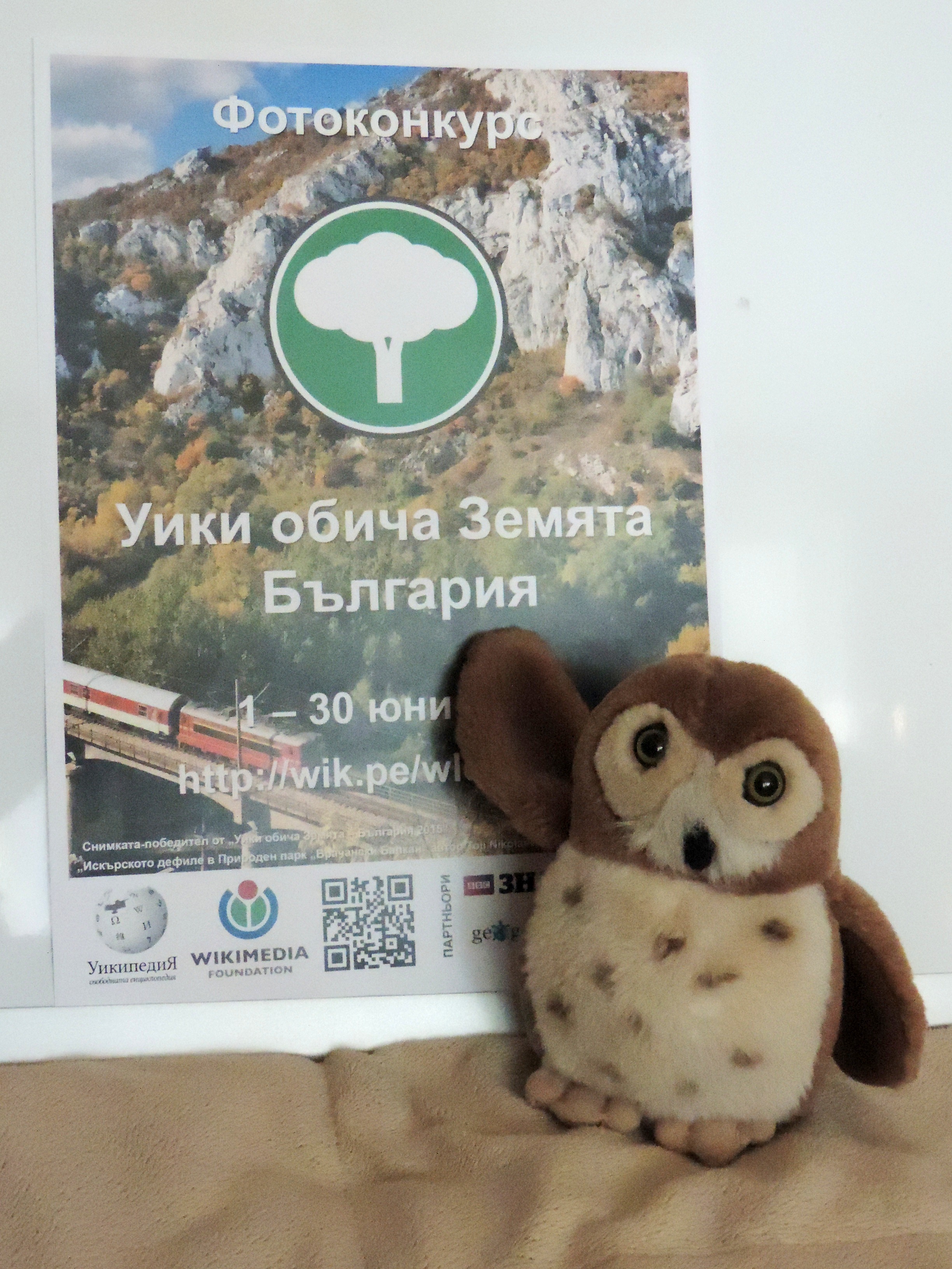
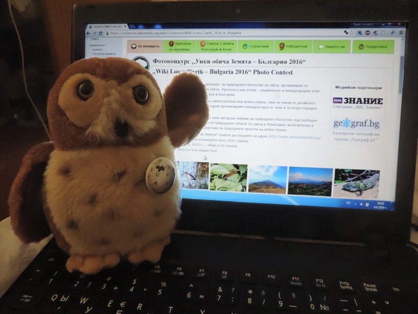
When Wozzy flew to us in the late evening of 31 May, a couple of hours before the start of the “Wiki Loves Earth 2016” in Bulgaria, he was approved unanimously by the organizers to become the contest’s mascot. He got the name ‘Wozzy’ from the Bulgarian translation of the abbreviation WLE, which sounds as ‘WOZ’.
Wozzy is pleased to get a photo in front of the “Wiki Loves Earth 2016 Bulgaria” poster.
Checking the field guide to the birds of Bulgaria, we could most accurately identify Wozzy as a Eurasian pygmy owl, representative of the Glaucidium passerinum species. From the Wikipedia article about the species, we learned that pygmy owls are the smallest owl species in Europe and Bulgaria, with body length of 15–19 cm, wingspan of 32–39 cm and weight up to about 80 grams. And, yes, with body length of 14 cm, wingspan of 19,5 cm and weight of 66 grams, our Wozzy is one really pygmy pygmy owl. When he understood which species we attribute him to, Wozzy didn’t mind and even hooted consentingly six times (well, not before we pressed the button on his belly).
Pygmy owls are wide spread in the boreal forests of Eurasia, and in the Central and Southern Europe they can only be found as a relict species in the mountains. The species’ conservation status is generally of least concern, but on the territory of Bulgaria it has been included in the Red Book of Endangered Species due to its paucity. Nesting pygmy owls have been detected in the three national parks in Bulgaria: “Central Balkan”, “Pirin” and “Rila”, and some other reserves like the Western Rhodopes and Slavyanka – all of them being locations included in the thematic scope of the “Wiki Loves Earth” photo contest, from where we encourage readers to send us their photos.
With his watchful eyes, Wozzy carefully proofreads the landing page of the contest.
Wozzy is far from the only mascot of a Wikimedian event or initiative. Flying here with us, he not only joined the organization team of “Wiki Loves Earth”, but also joined the merry band of plushies from the Wikimedia Cuteness Association: Percy Plush, Wendy the Weasel, Peter the Wikiplatypus, Erminig the Stoat, Punky and Lars, and others. We will introduce Wozzy face to face with the rest of the plushies after several weeks in Italy, where, at the end of June, Wikimania, the annual conference of the global Wikimedian community, will take place, along with the third annual Cuteathon.
Small waterfalls in Pelion, the mountain of Centaurs. Neoklis F., CC-BY-SA-4.0
Having begun in May 15th, Wiki Loves Earth in Greece is now at the halfway mark! The event is running in Greece for the first time, although parts of the required preparations started at least two years ago! For instance, an initial list of areas to be photographed was prepared in 2014.
Kastoria lake. Geosfot, CC-BY-SA-4.0
In order to run the Wiki Loves Earth contest, we needed a list of protected areas and natural reserves; national parks and forests, monuments of nature, RAMSAR sites, Natura 2000 sites etc. We found out that many of these areas overlapped with each other, or that smaller protected areas under the same definition were included in a wider protected area. In order to keep it simple, instead of merging these lists of protected areas into one big list, we chose to run the competition using the list of the Natura 2000 network, which includes most, if not all, of the areas of interest and is well documented. These sites constitute almost 30% of the land area of Greece and most of the population lives no more than 30 km away from anyone of them. Of course, although we are organising some photoexpeditions, we do not expect people to travel only for the competition. In Greece, excursions to the countryside are very frequent, during all seasons, and we expect that many contributions will be photos from previous such visits. Even people who are in areas around Greece just for tourism can contribute, as many of the islands and beaches are part of a protected natural area!
Skhinias and Marathon National Park, a step away from Athens. Oplats, CC-BY-SA-4.0
To this day we have seen great images from lakes, forests, beaches, habitats of birds, photos of many different species of flowers. This is great, as there was a lack of freely lincensed images for many locations in Greece. The images from Wiki Loves Earth will be useful for Wikipedia articles, but also for Wikidata items that we plan to create for each of these areas. What’s more, if the project is successful more people will know not only about Wikipedia, but also about Wikimedia Commons, and new users will be engaged in both projects. Until this day, participation is as expected, with more than 1100 new images from dozens of contributors throughout the country. There is also a lot of interest from the media, and it will bring in even more contributors. Running this photo contest in Greece is very important, as it is one of the limited number of ways to inform the public that they can contribute to Wikipedia not only by writing texts but also with their photos, cameras, or even smartphones. Although one would expect that Wiki Loves Monuments would be something very easy in a country whose culture and monuments span thousands of years, it is not. There is no Freedom of Panorama in Greece, and even taking photos of older monuments is a problem, because of the complex legislation regarding publishing rights for photos of monuments protected by the government. That is the reason we started photo contests by taking part in the European Science Photo Competition 2015, where we gained a lot of experience that we use for WLE. But Greece, except of being a country with long history, is also a land of sun, high mountains, deep forests, and long beaches. It is a habitat of a lot of unique spieces of birds, plants, and even sea turtles and seals in its archipelago. When we set our goal to 2500 images, it was commented that it is too high. We expect it to be fair. 🙂 Lilium chalcedonicum on Mount Olympus. EleKal, CC-BY-SA-4.0
Initially planned until May 31, the organizing committee of photography contest Wiki Loves Earth in Morocco, namely Wikimedia Morocco, announced that he decided to extend the duration of the contest for another week, so he closed the June 7. Given the large number of participants continues to grow and multiplying in a processive way uploaded photos.
Merzouga Oases by Hamza ZIDANE. 1 May 2016 (CC-BY-SA-4.0)
Prévue initialement jusqu’au 31 mai, le comité d’organisation du concours de photographie Wiki Loves Earth au Maroc, à savoir Wikimedia Morocco, a annoncé qu’il a décidé exceptionnellement de prolonger la durée du concours pour une autre semaine, ainsi il se clôtura le 7 juin prochain. Vu le grand nombre de participants qui ne cesse d’augmenter multipliant ainsi de manière processive les photos téléversées.
Lake in Ifrane by Mohammed-ali louanate. 12 May 2016 (CC-BY-SA-4.0)
مُقرر مبدئيا إلى غاية 31 مايو، أعلنت اللجنة المنظمة للمسابقة التصوير الفوتوغرافي ويكي تهوى الأرض في المغرب، ويكيميديا المغرب، أنها قررت استثنائيا تمديد فترة المسابقة لمدة أسبوع آخر، لتنتهي بذلك في 7 يونيو. نظرا للعدد الكبير من المشاركين الذي يتزايد مع الأيام، و الذي يرفع معه بشكل إضطرادي عدد الصور المشاركة
In this blog post we present you a personal insight on Wiki Loves Earth from the point of view of Australian Wikimedian User:Gnangarra
As we near the mid way part of WLE in Australia I thought I would share a few observations about what its like to run the event in a country for the first time. The first step took a little bit of work to establish but nothing one person can’t co-ordinate. This was followed by a review by a couple of very help people on the organising team who suggested a few additions. Finding judges for the Australian section was fairly easy because I was able to draw on people from GLAM partners who have existing relationships.
Uluru at dusk, Uluru-Kata Tjuta National Park; Kgbo; CC-BY-SA-4.0
Already for WLE we awaited for the first uploads on May 1st and what we received was the ultimate in Austalia’s iconic environment a place at the heart of our national psyche Uluru. From there we have had photos of penguins, pelicans, fish (no chips), seals, Koalas and echidnas. Of course the mandatory kangaroos that visitors to Austria oops I mean Australia are always looking for. With that comes another almost mandatory photo from Arakoon National Park of kangaroos bounding along a white sand beach.
Kangaroos at Trial Bay; Kazflaherty; CC-BY-SA-4.0
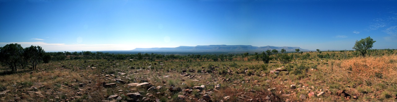
But of course WLE is about the Earth, its natural environment and places that are protected Australia has many of those, some very remote. There’s a litle track known as the Gibb River Road, its one the ultimate challenges for those into 4wding. Travelling along that road you can see the Barnett Range, so remote en Wikipedia doesn’t even have an article yet but we now have a photo, a beautiful 8000 px 53mb panorama that also demonstrates just how vast and remote parts of Australia really are.
The Barnett Range from the Gibb River Road in the Kimberley Region of Western Australia; Michel Hedley; CC-BY-SA-4.0
As we near that half way point what can I say about WLE; it is really easy to participate – all it takes is one person and a bit persuasion. You’ll be pleasantly surprised by what it produces.
When I put this to WMAU committee for approval for funding of prizes I said WLE could be considered a success with just 500 photos uploaded, and I’d be over the moon with 1000. We passed the 500 figure just 5 days in, now with 750 images uploaded WLE-au is well on the way to surpassing 1000 dare I dream of passing Australia’s most successful photo competition WikiTakes Waroona – 1849 images from 2013.
Today we present you an intimate story by one of the participants at the first edition of Wiki Loves Earth in Bulgaria in 2015 – Spasimir Pilev – who visited a number of protected areas in order to donate pictures of them to Wikimedia.
Thanks to its geographical position, Bulgaria has exceptionally rich and beautiful nature. Most interesting for me are the still well conserved ecosystems in the bordering mountains – Strandzha (bordering Turkey), Slavyanka (called also “Ali Botush”, bordering Greece), Belasica (bordering Greece and Republic Macedonia), Osogovo (bordering Republic Macedonia) and Ruy (bordering Serbia). While Bulgaria was part of the Eastern Bloc, these mountains fell in the 30-kilometre-wide border zone which required a special permission to get in. This is one of the reasons why nature has remained almost untouched by humans for decades.
During last year’s Wiki Loves Earth photo contest, in June, I decided to visit some protected nature reserves and areas in the inner parts of the country. My most visited destinations were the Sredna Gora and the West Rhodope Mountains.
“Eledzhik” protected area
My first trip was to the Eledzhik protected area, which is situated in the Ihtiman part of Sredna Gora and has an area of 668 ha. It contains protected fagus sylvatica forests. A starting point for the journey is the abandoned train station Nemirovo, named after the Bulgarian writer from the beginning of the 20th century Dobri Nemirov. The beginning of June is a wonderful time for taking pictures – the forest is green already, and many of the bushes are still in blossom. Wild strawberries have started to ripen. A few times I heard running hares near the river.
St. Marina protected area
During the following two or three weeks, I travelled to four less known protected areas, aiming to take pictures which would be suitable for illustrating Wikipedia articles. These areas are situated in the Western Rhodope Mountains. Some of them, as many other protected areas in Bulgaria, were historical sites in the past. In most of the cases, they are related to the Bulgarian resistance movement during World War II. Often the names of the protected areas in Bulgaria are very interesting. In the Western Rhodope Mountains I reached “Koritata” (The Trays) and “Ezeroto” (The Lake) where the object of preservation is their characteristic landscape; “Sveti Georgi”, which was created for protecting a natural field of summer snowflake (Leucojum aestivum) and “Marina” in which there are protected centuries-old sessile oaks. At the beginning it was declared a nature site, but later it was re-categorised as a protected area. Interesting are the still preserved foundations of a church from the Early Middle Ages, dedicated to St. Marina. Again thanks to the contest “Wiki Loves Earth”, I learned that these protected areas are part of a larger territory from a protected zone named “Yadenica” of the ecological network of the European Union Natura 2000 according to the Council Directive 92/43/EEC of 21 May 1992 on the conservation of natural habitats and of wild fauna and flora.
In some parts of the declared protected areas, endemic and relict species are preserved.
For my birthday, several days after the end of the competition, I made myself the present of climbing the highest peak of the tenth highest mountain in Bulgaria – the Big Bogdan peak in the Sredna Gora mountain. It belongs to the Bogdan reserve where oak forests of average age of 150 years are preserved.
For the rest of the days I had the good motivation to upload pictures from previous years to Wikimedia Commons – from the protected areas in Pirin, Balkan Mountains, Belasica, Rhodope Mountains. Many of them were used for illustrating numerous articles.
All of those protected areas – national parks, nature parks, reserves, protected areas, nature sights, protected “Natura 2000” zones – are of crucial importance for the preservation of nature and us, humans. Travelling with motor vehicles, hunting, and cutting down trees are forbidden, and walking is only permitted along the marked paths. This is important for Wikipedia, too, because the more is known about the importance of these unique areas, the bigger is the possibility to get a clear notion that they are of great importance for humans’ life, too, and thus help for their preservation.


 Dam Moulay Youssef, Marrakech Province by Simosure, freely licensed under CC BY-SA 4.0
 A landscape in Morocco by Othmane.elam, freely licensed under CC BY-SA 4.0
 An Addax in the station of aclimation Safia, south of Dakhla by Haytem93, freely licensed under CC BY-SA 4.0
 Erg Chebbi, Merzouga by Lefidele, freely licensed under CC BY-SA 4.0
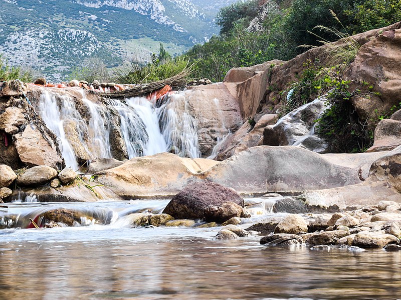
 Aïn Zarka, Tetouan Province by Mohamed Haddi, freely licensed under CC BY-SA 4.0
 The Cave of the Camel, Berkane Province by Soufianerrami, freely licensed under CC BY-SA 4.0
 Panorama of Djebel Toubkal by Webster93, freely licensed under CC BY-SA 4.0
 Merzouga by Hzidane10, freely licensed under CC BY-SA 4.0
 Barbary macaque in Azrou by Kamil-laghjichi, freely licensed under CC BY-SA 4.0
 Azilal by Marahlija, freely licensed under CC BY-SA 4.0
.jpg)


.jpg)

.jpg)

_m%C3%A2le_Ichkeul.jpg)
_2.jpg)
.jpg)
_05.jpg)


.jpg)
.jpg)
.jpg)


.jpg)