One more country choose their national winners. Switzerland presents the Top-10 list of best photos. If you like water landscapes and peaceful beautiful places there is no doubts you will like these shots.
Lake Maggiore

Lake Maggiore or Lago Verbano is a large lake located on the south side of the Alps. It is the second largest lake in Italy and the largest in southernSwitzerland.

The lake and its shoreline are divided between the Italian regions of Piedmont and Lombardy and the Swiss canton ofTicino. Located halfway between Lake Orta and Lake Lugano, Lake Maggiore extends for about 65 kilometres (40 miles) betweenLocarno and Arona.
Muttsee dam

Limmernsee with the temporary cablecar to erect the Muttsee dam. Muttsee dam was finished October 2014.
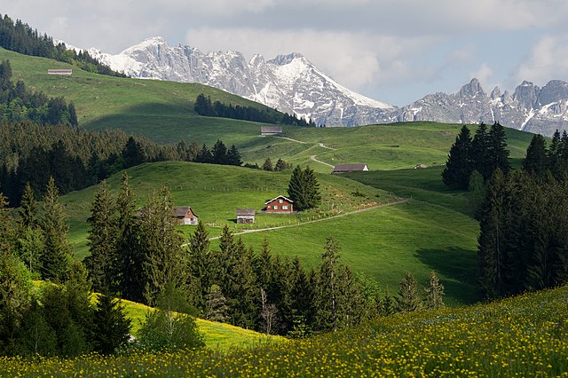
Nature Park Neckertal

Oeschinen Lake is a lake in the Bernese Oberland, Switzerland, 4 kilometres east of Kanderstegin the Oeschinen valley. At an elevation of 1,578 metres, it has a surface area of 1.1147 square kilometres. Its maximum depth is 56 metres.
The lake is fed through a series of mountain creeks and drains underground. The water then re-surfaces as the Oeschibach. Part of it is captured for electricity production and as water supply for Kandersteg.
In observations from 1931 to 1965, the elevation of the lake surface varied between 1,566.09 metres and 1,581.9 metres. The average seasonal variation was 12.2 metres.
The lake is generally frozen during five months, from December to May.
Fish in the lake include Arctic char, lake trout, rainbow trout. From January to March, ice fishing is popular.
Lake Biel

Lake Biel or Lake Bienne is a lake in the west of Switzerland. Together with Lake Morat and Lake Neuchâtel, it is one of the three large lakes in the Jura region of Switzerland.
The lake is 15 km long and up to 4.1 km wide. Its surface area is 39.3 km², the maximum depth 74 m. The lake is located at 429 metres above sea level.
Lake Biel has a catchment area of about 8,305 km². Water remains in the lake for an average of 58 days. The river Aare, the riverZihl/Thielle flowing from Lake Neuchâtel, the Twannbach draining water down from the surplombing first Jura mountain range and the river Suze draining water down from the Vallon de St. Imier, are the main tributaries. The river Aare was redirected into the lake in 1878, in order to prevent the flooding of the nearby area called “Seeland”, and drains the water out of the lake down to Bürenthrough a simultaneously man-made channel. The level of all three lakes is being controlled by a dam built across the channel, in Port.
Adula Park

Adula Park, a candidate for National Park certification, lies in the center of the Alpine arc. It is one of Switzerland’s largest contiguous landscapes untouched by significant human encroachment. The park’s eponym is the Adula Mountain, also known as Rheinwaldhorn, in the heart of the park.

The park comprises the large valleys on the edges of the cantons of Ticino and Graubünden, around the Adula Massif: the Blenio Valley, parts of the Surselva and the Hinterrhein as well as Graubünden’s Misox. Typical of the region are its small, but high, Alpine valleys such as Val Sumvitg, Val Calanca, Val Malvaglia, and Valle Santa Maria, among others.
The Greina

The Greina is a high mountain pass across the westernLepontine Alps, connecting Sumvitg in the canton of Graubünden in Switzerland and Olivone in the canton of Ticino. The pass lies between the Piz Medel on the north and Pizzo Marumo, Piz Terri on the south.
Greina is also a high plateau lying east of the pass, it is an alluvial site of national importance. The high plateau was in high risk of being flooded for a reservoir for many years. In the end this led to recompensation for the municipitalities of Vrin and Sumvitg as they have no income from this formerly planned powerplant. This compensation called Landschaftsrappen is augmented by a tax for powerplants.
Lake Constance

Lake Constance is a lake on the Rhine at the northern foot of the Alps, and consists of three bodies of water: the Obersee, the Untersee, and a connecting stretch of the Rhine, called the Seerhein.
The lake is situated in Germany, Switzerland and Austria near the Alps. Specifically, its shorelines lie in the German federal states of Bavaria and Baden-Württemberg, the Austrian federal state of Vorarlberg, and the Swiss cantons of Thurgau, St. Gallen and Schaffhausen. The Rhine flows into it from the south following the Austro-Swiss frontier.
References:
- https://en.wikipedia.org/wiki/Lake_Maggiore
- https://en.wikipedia.org/wiki/Oeschinen_Lake
- https://en.wikipedia.org/wiki/Lake_Biel
- https://en.wikipedia.org/wiki/Lago_di_Luzzone
- http://www.ticino.ch/en/commons/details/Project-National-Park-Adula/121436.html
- https://en.wikipedia.org/wiki/Greina
- https://en.wikipedia.org/wiki/Lake_Constance

Nature Park Neckertal has nothing to do with Oeschinen lake!
Wrong Reference with https://en.wikipedia.org/wiki/Oeschinen_Lake
Neckertal ist in St. Gallen not Bern !
See Description of Foto
‘Description
English: On the edge of the Naturpark Neckertal runs a hiking route from Bächli (854 m) to Hochalp (1529 m).
Deutsch: Am Rande des Naturparks Neckertal führt eine Wanderroute vom Bächli (854 m) zur Hochalp (1529 m).
Français : Sur le chemin du Hochalp (1529 m) depuis Bächli (854 m, commune de Hemberg) dans le Naturpark Neckertal en Suisse. Le chalet rouge (734’520 238’352), se trouve sur la commune d’Urnäsch dans le canton d’Appenzell Rhodes-Intérieures. Le photographe se trouve sur la commune de Hemberg dans le canton de Saint-Gall. Sommets faisant partie du massif de l’Alpstein: Silberplatten (2156 m), Stoss (2111 m) derrière le chalet rouge.’