
Do you like some fantastic landscapes that look unreal? We enjoy them a lot. Brazilian team presented their Top-10 creative photos. Such a strong and clean shots will impress you a lot.
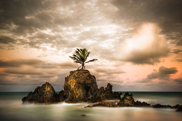
Sertão

The Sertão is one of the four sub-regions of the northeast of Brazil. Originally the term referred to the vast hinterlands of Asia and South America that Lusitanian explorers encountered. In Brazil it referred to backlands away from the Atlantic coastal regions where the Portuguese first settled in South America in the early sixteenth century. A Brazilian historian once referred to colonial life in Brazil as a “civilization of crabs”, as most settlers clung to the shoreline, with few trying to make inroads into the sertão. In modern terms, “sertão” refers to the semi-arid region inNortheastern Brazil comprising parts of the states of Alagoas, Bahia, Pernambuco, Paraíba, Rio Grande do Norte, Ceará,Maranhão, Piauí, and parts of northern Minas Gerais. The term Vaqueiro is similar to the generic use of “cowboy” in the United States.
Niterói City Park

The City Park in Niteroi is Located in an area of environmental protection The place Reserve one of the best views of Rio de Janeiro and Niteroi. From the top of the hill you can see the beaches of Niteroi (Camboinhas, Itaipu, Icarai and Jurujuba) and a spectacular view of Rio de Janeiro. If you want a little more emotion, on the Park you can jump from a gliding.
Abismo Anhumas

A cave in Bonito, Mato Grosso do Sul. This cave is equipped with a scuba diving platform and sunlight reaches down to the bottom during certain parts of the day.
Araucaria Forest

The Araucaria moist forests are a coniferous forest ecoregion of the Atlantic Forest Biome. The forest ecosystem is located in southern Brazil and northeastern Argentina.
The moist forests cover an area of 216,100 square kilometres (83,400 sq mi), encompassing a region of mountains and plateaus in the Brazilian states of São Paulo, Paraná, Santa Catarina, and Rio Grande do Sul, and extending into Misiones Province of Argentina.
The ecoregion lies above 500 metres (1,600 ft), rising to 1,600 metres (5,200 ft) elevation on the high slopes of the Serra da Mantiqueira.
The ecoregion is bounded by the Paraná-Paraíba interior forests to the north, west, and south, the Cerrado savannas and shrublands to the northeast, The Serra do Mar coastal forests to the east, and the Uruguayan savanna to the southwest.
Tambaba
Tambaba is an official nudist beach in Brazil, located on the Atlantic coast 20 km (12 mi) south of João Pessoa and 115 km (71 mi) north of Recife.
Tambaba is a short beach, about 1 km (0.6 mi). Until recently, the final access road was unpaved. However, as part of the infrastructure, development of the region the Ministro Abelardo Jurema highway (PB-008) has been completed and the route is paved from João Pessoato Tambaba. Tambaba sits in the municipality of Pitambui in the state of Paraiba and is considered one of the best beaches in Brazil. While famous for its nudist beach, it also has a public beach without nudism.
The area benefits from proximity of the recently expanded BR-101 route from Recife to Joao Pessoa to Natal, as well as to the other beaches of Tabatinga, Praia Bella and Coquerinho. This route is considered of high importance to the economy of Paiariba which is expanding due to the increase in tourism to the areas in and around Tambaba and the wider region including Joao Pessoa.
Tambaba Country Club Resort, a 150 hectare country club, is closely linked to the beach of Tambaba.
Lençóis Maranhenses National Park
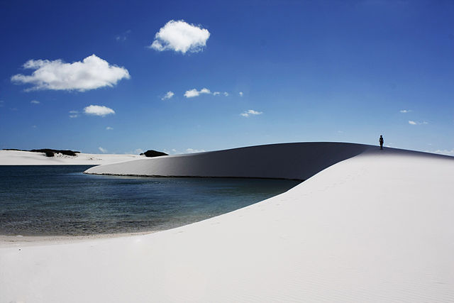
The Lençóis Maranhenses National Park is located in Maranhão state, in northeastern Brazil, just east of the Baía de São José. It is an area of low, flat, occasionally flooded land, overlaid with large, discrete sand dunes. It encompasses roughly 1,500 km2 (580 sq mi), and despite abundant rain, supports almost no vegetation. The area became a National Park on June 2, 1981.
Western honey bee
The western honey bee or European honey bee (Apis mellifera) is a species of honey bee. The genus name Apis is Latin for “bee”, andmellifera means “honey-bearing”.
Lizard

Lizards are a widespread group of squamate reptiles, with approximately over 6,000 species, ranging across all continents except Antarctica, as well as most oceanic island chains. The group, traditionally recognized as the suborder Lacertilia, is defined as all extant members of the Lepidosauria (reptiles with overlapping scales) that are neither sphenodonts (i.e., tuatara) nor snakes – they form an evolutionary grade. While the snakes are recognized as falling phylogenetically within the Toxicofera clade from which they evolved, the sphenodonts are the sister group to the squamates, the larger monophyletic group, which includes both the lizards and the snakes.
Fernando de Noronha

Fernando de Noronha is an archipelago of 21 islands and islets in the Atlantic Ocean, 354 km (220 mi) offshore from the Brazilian coast. The archipelago got its name from the Portuguese merchant Fernão de Loronha, to whom it was given by the Portuguese crown for services rendered regarding wood imported from Brazil. The main island has an area of 18.4 square kilometres (7.1 sq mi) and had a population estimated at 2,718 in 2012. The area is a specialmunicipality (distrito estadual) of the Brazilian state of Pernambuco (despite being closer to the state of Rio Grande do Norte),[2] with about 70% established in 1988 as a national maritime park.
Pancas
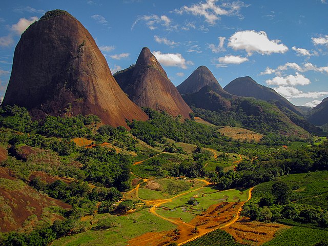
Pancas is a Brazilian municipality in the state of Espírito Santo. Its population was 20,025 (2005) and its area is 824 km².
It is situated on a tributary of the Doce River, in the northwest of the state. Locally it is known as a good spot for paragliding. The landscape around the town is distinguished by large numbers of granite inselbergs, and Pedra Agulha (“Needle Rock”) near the town is the second highest “chaminé” (high, vertical-sided granite rock) in Brazil – the highest being the famousCorcovado in Rio de Janeiro.
References:
- https://en.wikipedia.org/wiki/Sert%C3%A3o
- http://www.rioculturalsecrets.com/city-park-in-niteroi/
- http://seepicz.com/science-nature/abismo-anhumas-a-cave-in-bonito-mato-grosso-do-sul-in-brazil-this-cave-is-equipped-with-a-scuba-diving-platform-and-sunlight-reaches-down-to-the-bottom-during-certain-parts-of-the-day/
- https://en.wikipedia.org/wiki/Araucaria_moist_forests
- https://en.wikipedia.org/wiki/Tambaba
- https://en.wikipedia.org/wiki/Len%C3%A7%C3%B3is_Maranhenses_National_Park
- https://en.wikipedia.org/wiki/Western_honey_bee
- https://en.wikipedia.org/wiki/Lizard
- https://en.wikipedia.org/wiki/Fernando_de_Noronha
- https://en.wikipedia.org/wiki/Pancas