
Top-10 best photos of France most probably are the most diverse list of natural landscapes and life. Enjoy every single shot of it.
Jura Mountains Regional Natural Park

Jura Mountains Regional Natural Park is a French regional natural park located in the southwest of the Jura Mountain Range in France, on the French-Swiss border.
The park was created February 10, 1986, and at that time comprised 37 towns. As of 2005, that count is now 113 towns, with a total population of 71,000 inhabitants. The park covers an area of 165,000 hectares across three French departments: Ain, Doubs andJura.
Étang de Vaccarès
Étang de Vaccarès is a lake, or rather; a salt water lagoon (étang), in the wetlands of the Camargue in the delta of the RiverRhône in southern France.
The lake has an area of 65 km², and the depth is less than two meters. It is the northernmost, and also the largest of the lakes of the Camargue, and constitutes the principal element in the water control system of the Rhône delta, which depends upon a strict management of water resources, through pumping, irrigation and draining stations making a complex network of channels throughout the river delta.
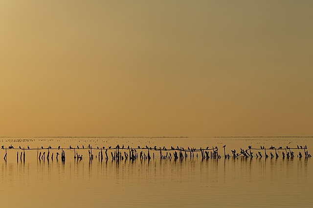
Banks of the pond of Scamandre

Salazie

Salazie is a volcanic caldera and commune (administrative division) in the department and region ofRéunion.
The first settlement of the area took place in 1829 after a cyclone had devastated the nearby coast, and the municipality of Salazie was formed in 1889. The name of the commune is potentially derived from the Malagasy word salazy, meaning ‘good encampment’.
Salazie lies in the middle of island, north-east of Piton des Neiges (the highest point on the island), in the Cirque de Salazie (actually a volcanic caldera). The commune is totally landlocked, and borders the communes of Bras-Panon, Cilaos, La Possession, Saint-André, Saint-Benoît, Saint-Denis, Sainte-Marie and Sainte-Suzanne.
Armorica Regional Natural Park

The Parc naturel régional d’Armorique (Breton: Park an Arvorig), or Armorica Regional Natural Park, is a rural protected arealocated in Brittany. The park land reaches from the Atlantic Ocean to hilly inland countryside. There are sandy beaches, swamps, strange rocks, fast rivers and the hills of Monts d’Arrée, all blended into one landscape. The park also includes three islands: Île de Sein, Molène and Ouessant.
The wildlife of the park is diverse and interesting to naturalists. There are sea birds on the islands, European otters and beavers in the rivers and swamps, and interesting birds of prey. In the marshes lives a species of rare carnivorous plant, the sundew, which captures unwary insects.
Pointe de Pen-Hir
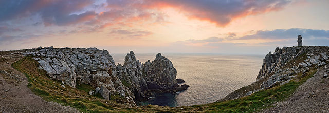
The pointe de Pen-Hir is a promontory of the Crozon peninsula in Brittany, to the south-west of Camaret-sur-Mer. On a clear day there are views to the Pointe du Raz and the islands of Sein and Ouessant and to Pointe Saint-Mathieu. The 70m tall cliffs are used for climbing.
It is the site of the Monument to the Bretons of Free France, known as the Cross of Pen-Hir and inaugurated by General Charles de Gaulle in 1960. It is intended to bear witness to the group of Free French Bretons who founded Sao Breiz in Great Britain during the Second World War.
Néouvielle National Nature Reserve

Néouvielle National Nature Reserve is a 2,313-hectare (5,720-acre) national nature reserve located in the Néouvielle massif.It ranges from 1,800 metres (5,900 ft) to 3,091 metres (10,141 ft). With a wide array of flora and fauna, it contains about 370animal species and 570 breeds of algae.
Located in the French Pyrénées (Midi-Pyrénées region, Hautes-Pyrénées department, near Saint-Lary-Soulan and Barèges in the Néouvielle massif), the reserve lies to the east of the Pyrenees National Park. It lies in the municipal territories of Vielle-Aure(enclave), Saint-Lary-Soulan (enclave) and Aragnouet. It is bordered to the west by the Néouvielle massif, to the south by theCap-de-Long and Orédon lakes, to the east by the lac de l’Oule and to the north by the col de Barèges. It includes the lakes ofAubert and Aumar. The reserve is in the lee of summits ranging from the pic de la Munia to the Arbizon massif and is generally exposed southwards, which induces a hotter and dryer microclimate allowing a life limit extension.
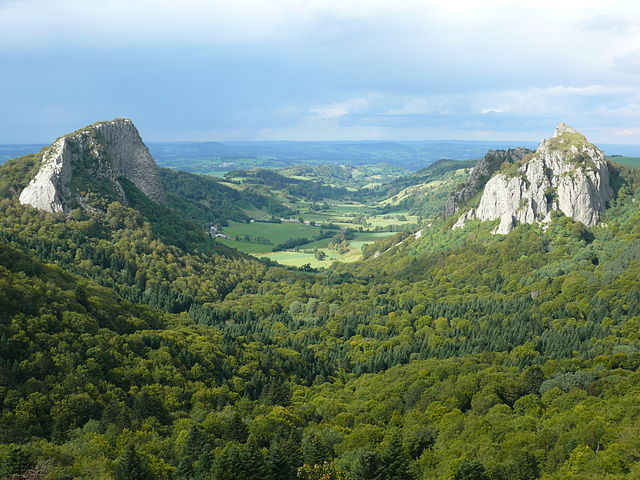
Puy de Sancy

Puy de Sancy is the highest mountain in the Massif Central. It is part of an ancient stratovolcano which has been inactive for about 220,000 years.
The northern and southern slopes are used for skiing, and a number of cablecars and skilifts ascend the mountain. Skiing has been practised on the mountain since the early 20th century. Two local priests traversed the Puy de Sancy on skis in 1905. In 1936, a cable car link was built from Mont-Dore to one of the needles just below the summit. In December 1965, a cable car accident injured ten passengers and killed seven others. Super-Besse is another ski resort, located on the southwestern slope.
The valley to the north is also the source of two streams called Dore and Dogne, which unite to form the Dordogne River, which flows through the nearby spa town of Mont-Dore and on to the Gironde estuary.
Lac de Grand-Lieu

Lac de Grand-Lieu is a lake located to the south-west of Nantes, in the Loire-Atlantique, France, and almost entirely in Saint-Philbert-de-Grand-Lieu. At an elevation of 5 m, its surface area is 62.92 km², making it the largest lake in France in winter, but second after Lac du Bourget in summer.
The lake is classified as a Local Nature Reserve, and use of boats on the lake are prohibited for all but a small number of licensed professional fishermen.
The Auvergne Volcanoes Regional Park
The Auvergne Volcanoes Regional Park is Europe’s largest regional park and also one of the oldest, it was established in 1977. A huge park comprised of outstanding landscapes, fauna and flora, the Auvergne Volcanoes Regional Nature Park (Parc naturel régional des Volcans d’Auvergne) also owes its distinctive identity to a rural society which has successfully preserved its ancestral know-how and culture, fully aware of the richness and fragility of its environment.
References:
- https://en.wikipedia.org/wiki/Parc_naturel_r%C3%A9gional_du_Haut-Jura
- https://en.wikipedia.org/wiki/%C3%89tang_de_Vaccar%C3%A8s
- https://en.wikipedia.org/wiki/Salazie
- https://en.wikipedia.org/wiki/Parc_naturel_r%C3%A9gional_d%27Armorique
- https://en.wikipedia.org/wiki/Pointe_de_Pen-Hir
- https://en.wikipedia.org/wiki/N%C3%A9ouvielle_National_Nature_Reserve
- https://en.wikipedia.org/wiki/Puy_de_Sancy
- https://en.wikipedia.org/wiki/Lac_de_Grand-Lieu
- http://www.auvergne-tourism.com/regional-nature-parks/the-auvergne-volcanoes-park-279-2.html