The top fifteen phenomenal winning photos from Wiki Loves Earth

Photo by Cedomir Zarkovic, CC BY-SA 4.0.

First place: The limestone of Stopića Cave, Serbia. Photo by Cedomir Zarkovic, CC BY-SA 4.0.

The tangy butterscotch glow of a limestone cave in Serbia soaking up the slanting sun. The emerald green of lush German forest and pond covered with lush weeds and trees. The stark white and blue of a Ukraine snowscape 2,028 meters above sea level, where snowy peaks meet cloud and sky.

The colors of nature burst from the 15 finalists of Wiki Loves Earth, the photo contest now in its third year of crowdsourcing gorgeous landscapes from more than 13,600 participants. The top 15 photos this year come from Serbia, Bulgaria, Nepal, Estonia, Ukraine, Spain, Austria, Brazil, Germany, and Thailand.

National judging in 26 regions sorted through 115,000 photos and sent the best to international judges from Ghana, Germany, South Africa, Kosovo, France, India, Estonia, Indonesia, and Bulgaria.

This year, the contest expanded to include a collaboration with the United Nations Educational, Scientific and Cultural Organization, better known by its acronym UNESCO. Contestants were invited to upload photos in a separate category for UNESCO biosphere reserves in 120 different countries.

You can see more about Wiki Loves Earth on its website, and this year’s jury report on Commons.

Photo by Diego Delso, CC BY-SA 4.0.

Second place: Pobiti Kamani, Bulgaria, the only desert in Eastern Europe. Photo by Diego Delso, CC BY-SA 4.0.

Photo by Patricia Sauer, CC BY-SA 4.0.

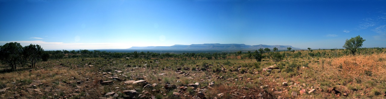
Third place: Tangye, Mustang, Nepal. Photo by Patricia Sauer, CC BY-SA 4.0.

Photo by Külli Kolina, CC BY-SA 4.0.

Fourth place: Ahja River, Estonia. Photo by Külli Kolina, CC BY-SA 4.0.

Photo by Khoroshkov, CC BY-SA 4.0.

Fifth place: Biały Słoń, the former Polish Astronomical and Meteorological Observatory, now located in Ukraine. Photo by Khoroshkov, CC BY-SA 4.0.

Photo by Tamara Kulikova, CC BY-SA 4.0.

Sixth place: Northern Inland Fuerteventura, Spain. Photo by Tamara Kulikova, CC BY-SA 4.0.

Photo by Kristoffer Vaikla, CC BY-SA 4.0.

Seventh place: Vääna River, Estonia. Photo by Kristoffer Vaikla, CC BY-SA 4.0.

Photo by Jörg Braukmann, CC BY-SA 4.0.

Eight place: Part of the Schladming Tauern. Photo by Jörg Braukmann, CC BY-SA 4.0.

Photo by Ryzhkov Sergey, CC BY-SA 4.0.

Ninth place: Tokivske waterfall in Ukraine. Photo by Ryzhkov Sergey, CC BY-SA 4.0.

Photo by Joao lara mesquita, CC BY-SA 4.0.

Tenth place: Lençóis Maranhenses National Park, Brazil. Photo by Joao lara mesquita, CC BY-SA 4.0.

Photo by Taras Dut., CC BY-SA 4.0.

Eleventh place: the same location as #5, but taken on a cold winter day. Photo by Taras Dut., CC BY-SA 4.0.

Photo by Andreas Weith, CC BY-SA 4.0.

Twelfth place: Wettenberger Ried, a protected forest in Germany. Photo by Andreas Weith, CC BY-SA 4.0.

Photo by KOSIN SUKHUM, CC BY-SA 4.0.

Thirteenth place: Khao Sam Roi Yot National Park in Thailand. Photo by KOSIN SUKHUM, CC BY-SA 4.0.

Photo by Rafael Rodrigues Camargo, CC BY-SA 4.0.

Fourteenth place: Terra Ronca State Park, Brazil. Photo by Rafael Rodrigues Camargo, CC BY-SA 4.0.

Photo by Vladimir Mijailović, CC BY-SA 4.0.

Fifteenth place: Tara in Serbia. Photo by Vladimir Mijailović, CC BY-SA 4.0.

Jeff Elder, Digital Communications Manager
Wikimedia Foundation

Originally published on the Wikimedia blog at https://blog.wikimedia.org/2016/11/25/wiki-loves-earth-2016-winners/.

Continue reading “The top fifteen phenomenal winning photos from Wiki Loves Earth”

The international round has begun

Mount Kanchenjunga seen from Goechala. Photo by Yoghya, freely licensed under CC BY-SA 4.0

A record number of over 110.000 pictures, taken by over 13.000 uploaders in 26 participating countries and in biosphere reserves of our partner UNESCO were uploaded during this year’s national round of Wiki Loves Earth! Each of the participating communities chose their best ten pictures which represent them in the international round of the competition. Now the nine-member jury has the hard task to choose the best pictures worldwide.

The jury consist of nine members, who live all around the globe – Dietmar Bartz, Katya Zareva-Simeonova, Besnik Hamiti, Chris Woodrich, Doris Anson-Yevu, Isla Haddow-Flood, Jeevan Jose, Janno Loide, and Qunli Han. They will choose the best pictures, which represent an identified natural monument, natural park, protected area, etc., including pictures of animals taken there. All of the pictures, uploaded during Wiki Loves Earth were published under a free licence.

Lake Ohrid. Photo by Fation Plaku, freely licensed under CC BY-SA 4.0

Most pictures were uploaded in India – 31.317, followed by Germany with 18.161 and Ukraine with 11.475. The highest number of uploaders was found in India with 6.318, followed by Germany with 1.108 and Pakistan with 1.098. For India this year was the second time it participated and its results have been impressive. Among the newcomers, Australia had the best results with 3.509 pictures uploaded by 595 people. The other states which participated for the first time this year were Greece, Albania, Moldova, and Kosovo.

Wiki Loves Earth 2016 completed successfully in Moldova

The winning image of the Burlănești Defile; Alex Prodan, CC-BY-SA-4.0

This year Moldova had the Wiki Loves Earth organized for the first time. During a span of one month, amateur and professional photographers from Moldova had the chance to upload their photos of natural heritage monuments of the country, in the same time contributing to the scarce free media collection of Moldovan nature online.

Socola, Șoldănești, second placed; Balan Anton, CC-BY-SA-4.0

During a month of contest, the organizers received 600 images depicting 70 natural monuments and protected areas. These are small numbers on a global scale, but decent numbers for Moldova: prior to the contest, only 7 natural monuments had illustrations on Wikimedia Commons. The uploaded files were being added to the corresponding articles immediately, making Moldova the best participating country in terms of media usage (23% of files are used in articles).

A waterfall in Saharna landscape reserve, third placed; Botnari Stefan, CC-BY-SA-4.0

The promotion efforts gathered a small amount of actual uploaders. As much as 17 people had at least one valid upload. The jury, consisting of two local professional photographers and one Wikipedian, identified the ten best ten works and announced them at the end of July.

Awarding the first and second place; Visem, CC-BY-SA-4.0

The winners and participants were invited to attend the awarding ceremony on on July 24 at the Hasdeu municipal library of Chișinău. During the meetup, attendants had the opportunity to see a mini-exposition of winning photographies, chat with some of the participants, and also ask questions about Wikipedia, specifically Wikipedia activities connected to Wikipedia in Moldova. There were voices expressing interest for an eventual possible Wiki Loves Monuments in the country.

Awarding third place; Visem, CC-BY-SA-4.0
Awarding the X-style special prize; Gikü, CC-BY-SA-4.0

Photo contest winners in Morocco

Please welcome the winning pictures of Wiki Loves Earth in Morocco!

Morocco has participated in Wiki Loves Earth 2015 and around 1700+ pictures have been uploaded under creative commons license through this event. This year we received around 3 thousand photos and it’s just great! 19 are already recognized as quality images on Wikimedia Commons and more to come.

577 participants took part in the contest and almost all of them are newbies. We are happy to introduce new people into the wiki world 🙂 Lets work on using these images, we now have, in Wikipedia articles!

Ten best pictures of Morocco this year you see below. You are free to reuse them, but please mention the author and the license.

Wiki Loves Earth in Greece – tourists are welcome to participate!

Small waterfalls in Pelion, the mountain of Centaurs. Neoklis F., CC-BY-SA-4.0

Having begun in May 15th, Wiki Loves Earth in Greece is now at the halfway mark! The event is running in Greece for the first time, although parts of the required preparations started at least two years ago! For instance, an initial list of areas to be photographed was prepared in 2014.

Kastoria lake. Geosfot, CC-BY-SA-4.0

In order to run the Wiki Loves Earth contest, we needed a list of protected areas and natural reserves; national parks and forests, monuments of nature, RAMSAR sites, Natura 2000 sites etc. We found out that many of these areas overlapped with each other, or that smaller protected areas under the same definition were included in a wider protected area. In order to keep it simple, instead of merging these lists of protected areas into one big list, we chose to run the competition using the list of the Natura 2000 network, which includes most, if not all, of the areas of interest and is well documented. These sites constitute almost 30% of the land area of Greece and most of the population lives no more than 30 km away from anyone of them. Of course, although we are organising some photoexpeditions, we do not expect people to travel only for the competition. In Greece, excursions to the countryside are very frequent, during all seasons, and we expect that many contributions will be photos from previous such visits. Even people who are in areas around Greece just for tourism can contribute, as many of the islands and beaches are part of a protected natural area!

Skhinias and Marathon National Park, a step away from Athens. Oplats, CC-BY-SA-4.0

To this day we have seen great images from lakes, forests, beaches, habitats of birds, photos of many different species of flowers. This is great, as there was a lack of freely lincensed images for many locations in Greece. The images from Wiki Loves Earth will be useful for Wikipedia articles, but also for Wikidata items that we plan to create for each of these areas. What’s more, if the project is successful more people will know not only about Wikipedia, but also about Wikimedia Commons, and new users will be engaged in both projects. Until this day, participation is as expected, with more than 1100 new images from dozens of contributors throughout the country. There is also a lot of interest from the media, and it will bring in even more contributors. Running this photo contest in Greece is very important, as it is one of the limited number of ways to inform the public that they can contribute to Wikipedia not only by writing texts but also with their photos, cameras, or even smartphones. Although one would expect that Wiki Loves Monuments would be something very easy in a country whose culture and monuments span thousands of years, it is not. There is no Freedom of Panorama in Greece, and even taking photos of older monuments is a problem, because of the complex legislation regarding publishing rights for photos of monuments protected by the government. That is the reason we started photo contests by taking part in the European Science Photo Competition 2015, where we gained a lot of experience that we use for WLE. But Greece, except of being a country with long history, is also a land of sun, high mountains, deep forests, and long beaches. It is a habitat of a lot of unique spieces of birds, plants, and even sea turtles and seals in its archipelago. When we set our goal to 2500 images, it was commented that it is too high. We expect it to be fair. 🙂
Lilium chalcedonicum on Mount Olympus. EleKal, CC-BY-SA-4.0

Observation on Wiki Loves Earth from Australia

In this blog post we present you a personal insight on Wiki Loves Earth from the point of view of Australian Wikimedian User:Gnangarra

As we near the mid way part of WLE in Australia I thought I would share a few observations about what its like to run the event in a country for the first time.  The first step took a little bit of work to establish but nothing one person can’t co-ordinate.  This was followed by a review by a couple of very help people on the organising team who suggested a few additions. Finding judges for the Australian section was fairly easy because I was able to draw on people from GLAM partners who have existing relationships.

Uluru at dusk, Uluru-Kata Tjuta National Park
Uluru at dusk, Uluru-Kata Tjuta National Park; Kgbo; CC-BY-SA-4.0

Already for WLE we awaited for the first uploads on May 1st and what we received was the ultimate in Austalia’s iconic environment a place at the heart of our national psyche Uluru.  From there we have had photos of penguins, pelicans, fish (no chips), seals, Koalas and echidnas.  Of course the mandatory kangaroos that visitors to Austria oops I mean Australia are always looking for. With that comes another almost mandatory photo  from Arakoon National Park of kangaroos bounding along a white sand beach.

Kangaroos at Trial Bay
Kangaroos at Trial Bay; Kazflaherty; CC-BY-SA-4.0

But of course WLE is about the Earth, its natural environment and places that are protected Australia has many of those, some very remote. There’s a litle track known as the Gibb River Road, its one the ultimate challenges for those into 4wding. Travelling along that road you can see the Barnett Range, so remote en Wikipedia doesn’t even have an article yet but we now have a photo, a beautiful 8000 px 53mb panorama that also demonstrates just how vast and remote parts of Australia really are.

The Barnett Range from the Gibb River Road in the Kimberley Region of Western Australia
The Barnett Range from the Gibb River Road in the Kimberley Region of Western Australia; Michel Hedley; CC-BY-SA-4.0

As we near that half way point what can I say about WLE; it is really easy to participate – all it takes is one person and a bit persuasion. You’ll be pleasantly surprised by what it produces.

When I put this to WMAU committee for approval for funding of prizes I said WLE could be considered a success with just 500 photos uploaded, and I’d be over the moon with 1000. We passed the 500 figure just 5 days in, now with 750 images uploaded WLE-au is well on the way to surpassing 1000 dare I dream of passing Australia’s most successful photo competition WikiTakes Waroona – 1849 images from 2013.

.

Protected areas in Bulgaria – a story by a participant at Wiki Loves Earth 2015

Today we present you an intimate story by one of the participants at the first edition of Wiki Loves Earth in Bulgaria in 2015 – Spasimir Pilev – who visited a number of protected areas in order to donate pictures of them to Wikimedia.

Thanks to its geographical position, Bulgaria has exceptionally rich and beautiful nature. Most interesting for me are the still well conserved ecosystems in the bordering mountains – Strandzha (bordering Turkey), Slavyanka (called also “Ali Botush”, bordering Greece), Belasica (bordering Greece and Republic Macedonia), Osogovo (bordering Republic Macedonia) and Ruy (bordering Serbia). While Bulgaria was part of the Eastern Bloc, these mountains fell in the 30-kilometre-wide border zone which required a special permission to get in. This is one of the reasons why nature has remained almost untouched by humans for decades.

During last year’s Wiki Loves Earth photo contest, in June, I decided to visit some protected nature reserves and areas in the inner parts of the country. My most visited destinations were the Sredna Gora and the West Rhodope Mountains.

“Eledzhik” protected area

My first trip was to the Eledzhik protected area, which is situated in the Ihtiman part of Sredna Gora and has an area of 668 ha. It contains protected fagus sylvatica forests. A starting point for the journey is the abandoned train station Nemirovo, named after the Bulgarian writer from the beginning of the 20th century Dobri Nemirov. The beginning of June is a wonderful time for taking pictures – the forest is green already, and many of the bushes are still in blossom. Wild strawberries have started to ripen. A few times I heard running hares near the river.

St. Marina protected area

During the following two or three weeks, I travelled to four less known protected areas, aiming to take pictures which would be suitable for illustrating Wikipedia articles. These areas are situated in the Western Rhodope Mountains. Some of them, as many other protected areas in Bulgaria, were historical sites in the past. In most of the cases, they are related to the Bulgarian resistance movement during World War II. Often the names of the protected areas in Bulgaria are very interesting. In the Western Rhodope Mountains I reached “Koritata” (The Trays) and “Ezeroto” (The Lake) where the object of preservation is their characteristic landscape; “Sveti Georgi”, which was created for protecting a natural field of summer snowflake (Leucojum aestivum) and “Marina” in which there are protected centuries-old sessile oaks. At the beginning it was declared a nature site, but later it was re-categorised as a protected area. Interesting are the still preserved foundations of a church from the Early Middle Ages, dedicated to St. Marina. Again thanks to the contest “Wiki Loves Earth”, I learned that these protected areas are part of a larger territory from a protected zone named “Yadenica” of the ecological network of the European Union Natura 2000 according to the Council Directive 92/43/EEC of 21 May 1992 on the conservation of natural habitats and of wild fauna and flora.

In some parts of the declared protected areas, endemic and relict species are preserved.

For my birthday, several days after the end of the competition, I made myself the present of climbing the highest peak of the tenth highest mountain in Bulgaria – the Big Bogdan peak in the Sredna Gora mountain. It belongs to the Bogdan reserve where oak forests of average age of 150 years are preserved.

For the rest of the days I had the good motivation to upload pictures from previous years to Wikimedia Commons – from the protected areas in Pirin, Balkan Mountains, Belasica, Rhodope Mountains. Many of them were used for illustrating numerous articles.

All of those protected areas – national parks, nature parks, reserves, protected areas, nature sights, protected “Natura 2000” zones – are of crucial importance for the preservation of nature and us, humans. Travelling with motor vehicles, hunting, and cutting down trees are forbidden, and walking is only permitted along the marked paths. This is important for Wikipedia, too, because the more is known about the importance of these unique areas, the bigger is the possibility to get a clear notion that they are of great importance for humans’ life, too, and thus help for their preservation.

“Uvac” Special Nature Reserve

“Uvac” Special Nature Reserve

“Uvac” Special Nature Reserve is a protected natural asset of great importance, situated in south-western Serbia in the region of Stari Vlah – Raška high plateau, set between Mt. Javor in the Northeast and Mt. Zlatar massif in the Southwest. It has been protected since 1971 and occupies the territory of 7543 ha in total. The minimum altitude in the reserve is 760 m above sea level, and the maximum – 1322 m.

Major morphological feature of the reserve is the Uvac River canyon valley which includes the valleys of its tributaries. The special value of canyon parts of the river valley are curving meanders. The relative height of meander heads is 100 m at places.

The surrounding is characterised by karst surface with numerous karst formations: plains, depressions, sinkholes, rock shelters, caves and potholes. Caves are numerous and vary in size, including Usak Cave System, the largest known cave system in Serbia (6185 m). Caves are very rich in speleothem deposited by the action of dripping water to form stalactites, stalagmites, columns, draperies etc.

Hanging bridge in “Uvac” Nature Reserve, second placed in Wiki Loves Earth 2015 in Serbia

“Uvac” Special Nature Reserve is distinguished by the presence of 104 bird species. Most important of all is the griffon vulture, one of the two vulture species that are still nesting in Serbia.

Variety of intact habitats, presence of endemic, rare and endangered flora and fauna species have special importance in terms of preservation of biodiversity and geodiversity and, by itself in terms of development and promotion of tourism potential of the reserve.

Sources

Steinerne Rinnen – karst phenomena in Germany

Calcareous tufa gutter by Derzno, CC-BY-SA-3.0

Steinerne Rinnen” or calcareous tufa gutters are rare karst phenomena. The main occurrence of such kind of gutters is in the hilly areas of Franconia, in the northern part of Bavaria in Germany. It would be interesting to know if such geologic gutters can be found elsewhere as well as the local names for such formations. The formation of such karsts require a fountain rich with dissolved carbonate, a terrain steep enough for a fast-running stream, and some mosses or algae in or near the water. In this case, sedimented tufa slowly forms a certain kind of a wall-like structure with the water-stream on top of it. The longest gutter in Germany is approximately 150 m long. The tallest known gutter reaches a height of 5.4 m. The natural protection state of a “Steinerne Rinnen” can be different. Sometimes they are protected as a natural monument or registered by a so called geotope. Others are simply part of a larger protected area.