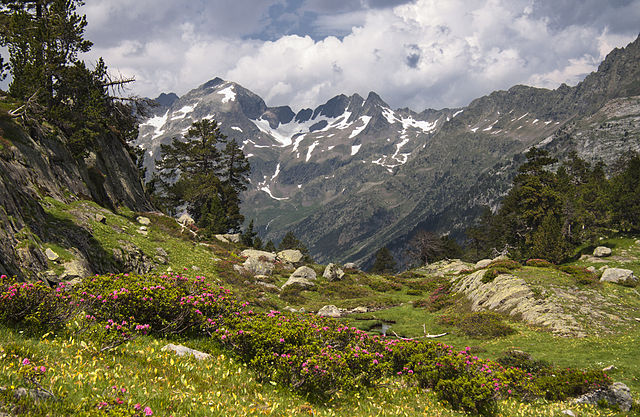
Spanish national winners show great diversity of landscapes and seasons. Spanish participants of WLE have shown a big interest in the competition this year. You will find there wild nature, stunning panoramic shots, mountains, woods, rivers and waterfalls.
Spanish ibex

The Iberian ibex, Spanish ibex, Spanish wild goat, or Iberian wild goat is a species of ibex with foursubspecies. Of these, two can still be found on the Iberian Peninsula, but the remaining two are now extinct. The Portuguese subspecies became extinct in 1892 and the Pyrenean subspecies became extinct in 2000. An ongoing project to clone to the Pyrenean subspecies resulted in one clone being born alive in January 2009. This is the first taxon to become “un-extinct”, although the clone died a few minutes after birth due to physical defects in lungs.
Garajonay National Park

Garajonay National Park is located in the center and north of the island of La Gomera, one of the Canary Islands (Spain). It was declared a national park in 1981 and aWorld Heritage Site by UNESCO in 1986. It occupies 40 km2 (15 sq mi) and it extends into each of the six municipalities on the island.
The park is named after the rock formation of Garajonay, the highest point on the island at 1,487 m (4,869 feet). It also includes a small plateau whose altitude is 790-1,400 m above sea level.
The park provides the best example of Canarian laurisilva, a humid subtropical forest that in the Tertiary covered almost all of Southern Europe. It is also found on the Azores and the Madeira Islands. Laurus azorica, known as Azores laurel, or by the Portuguese names louro, loureiro, louro-da-terra, and louro-de-cheiro, can be found in the park, as well as Laurus novocanariensis, known as Canary laurel. Although named as a single type of forest, the national park englobes several varieties of forests.
Torcal de Antequera

El Torcal de Antequera is a nature reserve in the Sierra del Torcal mountain range located south of the city of Antequera, in theprovince of Málaga off the A45 road in Andalusia, Spain. It is known for its unusual landforms, and is one of the most impressivekarst landscapes in Europe. The area was designated a Natural Site of National Interest in July 1929, and a Natural Park Reserve of about 17 square kilometres was created in October 1978.
Foz de la Porquera

Bardenas Reales

The Bardenas Reales is a semi-desert natural region, or badlands, of some 42,000 hectares (100,000 acres) in southeast Navarre (Spain). The soils are made up of clay, chalkand sandstone and have been eroded by water and wind creating surprising shapes, canyons, plateaus, tabular structures and isolated hills, called seamounts. Bardenas lacks urban areas, vegetation is scarce and the many streams that cross the territory have a markedly seasonal flow, staying dry most of the year.
Natural Park of Posets-Maladeta

The Natural Park of Posets-Maladeta is a Natural park located in northern Province of Huesca, Aragón, northeastern Spain. It is set within the Pyrenees .
The Natural Park of Posets-Maladeta is at elevations from 1,500 metres (4,900 ft) in the valley, to over 3,300 metres (10,800 ft) on the highest mountains of the .
Mount Aneto, at 3,404 metres (11,168 ft) in elevation, is the highest peak of the Pyrenees Mountain Range System.
Other important peaks in the park include: Posets Peak at 3,371 metres (11,060 ft); and Mount Maladeta at 3,312 metres (10,866 ft).
Nublo Rural Park

The Roque Nublo Rural Park is located on the heart of the island of Gran Canaria holding the municipalities of Artenara, Mogán, San Bartolomé de Tirajana, San Nicolás, Tejeda, Valleseco and Vega de San Mateo.
In this park many native protected species inhabit. The wide pine trees, its puddles and coastal cliffs confer an exceptional beauty landscape.
Roque Nublo is a singular site and an emblematic symbol to Gran Canaria. This colossal rock was adored by old aboriginal. You’ll be able to access through the base by a steep ground trail.
It’s important to mention that this place usually has a natural phenomenon known as the “Sea of Waves” which stagnate on the north slope of the mountains. The south is usually clear.
Tablas de Daimiel National Park

Tablas de Daimiel National Park is a wetland on the La Mancha plain, a mainly arid area in the province of Ciudad Real. With an area of about 2,000 ha, the park is the smallest of Spain’s fifteen national parks.The protected area is in the process of being expanded outside the original nature reserve to include neighbouringdryland farming areas. The expansion is part of efforts to improve the condition of the wetland, which has been damaged by over-exploitation of water resources.
Saja and Nansa valleys

The Valleys of the Saja and Nansa Rivers comprise an administrative comarca in Cantabria, Spain. It is formed by the valleys of said rivers, each one being a natural comarca of its own.
Tabernas Desert

The Tabernas Desert is one of Spain’s semi-deserts, located within Spain’s southeasternprovince of Almería. Almeria is the driest region of Europe, with the continent’s only true desert climate where annual rainfall reaches levels as low as 156 mm in coastal areas. The Tabernas desert is located in the interior, about 30 kilometers (19 mi) north of the provincial capital, Almería, in the Tabernas municipality. Due to its altitude it has slightly higher annual rainfall (around 200mm per year) and lower annual average temperature than Almeria’s coastal desert. It is protected as awilderness area (paraje natural) spanning 280 square kilometres (110 square miles).
References:
- https://en.wikipedia.org/wiki/Spanish_ibex
- https://en.wikipedia.org/wiki/Garajonay_National_Park
- https://en.wikipedia.org/wiki/Torcal_de_Antequera
- https://en.wikipedia.org/wiki/Bardenas_Reales
- https://en.wikipedia.org/wiki/Natural_Park_of_Posets-Maladeta
- http://www.visitcanaryislands.org/roque-nublo-rural-park
- https://en.wikipedia.org/wiki/Saja_and_Nansa_valleys
- https://en.wikipedia.org/wiki/Tabernas_Desert
